An engineering feat of ingenuity allowed the aqueduct that served as Jerusalem’s main water supply to be in use for 2000 years. A new section of it was found in Armon Hanatsiv.
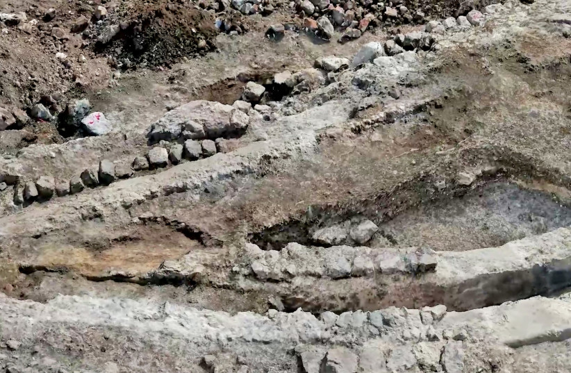
For two millennia, the city of Jerusalem received its main water supply from a low-level aqueduct that wound its way along a 21-km. (13-mile) route from Solomon’s Pool south of Bethlehem all the way to the Temple Mount in the capital’s Old City.
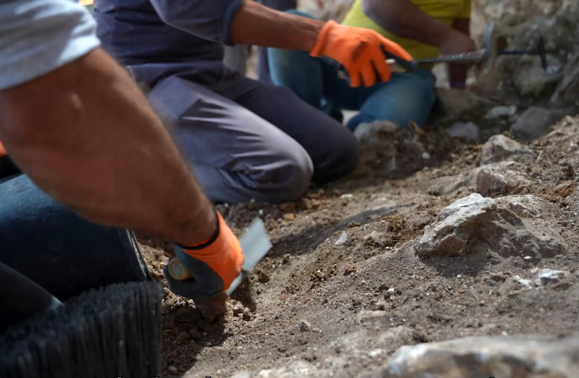
A new segment of this aqueduct has recently been exposed in an Antiquities Authority (IAA) excavation directed by Alexander Wiegmann of the IAA under Alkachi Street in the Armon Hanatziv neighborhood, in a joint project with the Jerusalem Municipality and the Moriah Jerusalem Development Corporation.
Hasmonean engineering
This feat of ancient engineering ingenuity was built with a slight gradient, descending just over a meter along every kilometer on average, with a 30-meter difference in elevation. It was initiated by the Hasmonean kings to increase the water supply to Jerusalem, particularly to the Temple Mount.
Jerusalem’s location as an ancient city was chosen because of its proximity to the large, reliable water source of the Gihon Spring.
Ya’akov Billig of the IAA, who has researched the ancient aqueducts to Jerusalem and took part in the recent excavation, pointed out, however, that the spring was situated on the vulnerable lower slopes of the mountain.
“Cities were generally built on more strategic higher ground, and the spring, being situated low on the mountain slope, was a vulnerable location,” he said.
So how did the aqueduct last?
Over time, different solutions were found for keeping the water secure, including fortifications, tunnels and cisterns, he added.
As the population grew and technology improved, bringing water from a larger source farther from the city was possible, Billig said, depending on the accuracy of their measurements of the difference in elevations.
“They had to somehow manage to know in antiquity what the difference in elevation was over great distances. Water only moves from up to down,” he said. “It is a matter of technology and of the instruments in measuring the relative altitudes and choosing the proper route it can follow with the water constantly going downhill.”
They had to somehow manage to know in antiquity what the difference in elevation was over great distances. Water only moves from up to down.
Yaakov Billig, Isarel Antiquities Authority
Billig said that the low-level aqueduct was the first in a series that kept getting longer and more sophisticated.
Due to the newly exposed aqueduct’s ingenuity and quality, it continued to be used off and on – depending on whether the ruling authorities had the will and budget to maintain it – until the British Mandate 100 years ago when the invention of electric pumps replaced it, he said.
There were two aqueducts that brought water from Solomon’s Pools, located between Bethlehem and Efrat to Jerusalem, Billig said: the Low-Level Aqueduct and the High-Level Aqueduct.
The High-Level Aqueduct was built later and began at a higher elevation, reaching a higher destination point in the city, he said.
“It was more sophisticated – maybe too sophisticated to keep it up – and it went out of use after 500 years, at the end of the Byzantine period around 1,500 years ago, so it is not as well known.”
What else are the archaeologists finding?
Portions of it are also slowly being uncovered, and several sections are visible in places such as Givat Hamatos, Hebron Road and Ramat Rahel in Jerusalem and in Bethlehem. One portion was recently found in Gilo.
“It amazes us to think how they managed in antiquity to make accurate measurements of elevation along such a long distance, choosing the route along the mountainous terrain and calculating the necessary gradient, all without the modern sophisticated instruments we have today,” Billig said.
“It was really a magnificent and fascinating engineering feat that they managed with the old-fashioned instruments they had then – to accurately measure and calculate and execute this project – and it worked,” he said. “And since it was planned and constructed so well, it was used on and off for 2,000 years.”
Following the excavation, conservation experts will do preservation work on the remains of the aqueduct and it will then be opened to the public.
Content retrieved from: https://www.jpost.com/archaeology/article-707974.